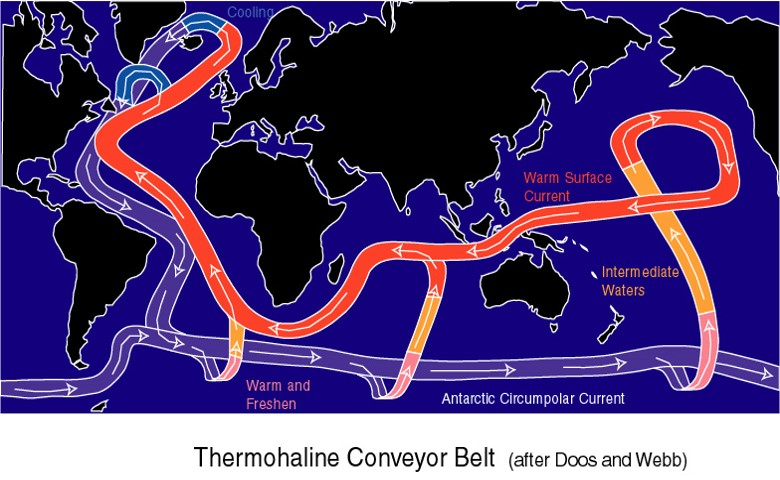
It helps to have members with good contacts, and this is how (Emeritus) Professor Harry Bryden of Southampton University came to be talking to Coastwise members about one important aspect of oceanography – the reason for the Gulf Stream, and what might happen if it stopped.
Previously known, snappily, as the Thermohaline Conveyor Belt, and now as the Atlantic Meridional Overturning Circulation (AMOC) this system of currents in three dimensions is part of a global oceanic flow system that is driven by temperature differences and saline variations.
Prof Bryden really is an expert in the field and spent a significant amount of time at the Woods Hole Oceanographic Institute before moving to the UK. He has the gift of simple and non-patronising explanation of complex issues, appreciated by one of the largest Coastwise attendances in the last year.
Members learned that the presence of the Gulf Stream was deduced by Ben Franklyn, ambassador to the UK in 1770 because postal packet ships took 2 weeks longer on the E-W crossing than W-E. This was already known informally by Newfoundland whalers, who used different routes to use the currents, not to be confused with the equivalent benefit offered by the Trade Winds.
The answer to the crucial question "what if the Gulf Stream stopped" is that after 100 years without it modelling shows that the average ambient temperature would be 10 degrees C lower !
Prof Bryden outlined the processes used in obtaining oceanographic data, particularly ARGO floats with their mechanism to send data from depths of 2000m over a drift of approx. 200miles. An adaptation of this is the "Ocean Glider", whose position is controllable to some extent. However, reliable 3-D data sets are only 11 years old now, and, as with all science, more work and dat is needed to allow us to fully understand the effect of the oceans on climate and other human influences.
Pictured R are the (top) flow mechanisms of the Atlantic, Indian and Southern Oceans, the flow in the Atlantic shown as a cross-section, and (bottom) a modern ocean sampling and dat collection instrument.

